
The Wakehurst Parkway
- 1 day ago
- 10 min read
Gridlock, ghosts and gore: the horrible history of Sydney’s most mysterious roadway, the Wakehurst Parkway.
By ALEC SMART
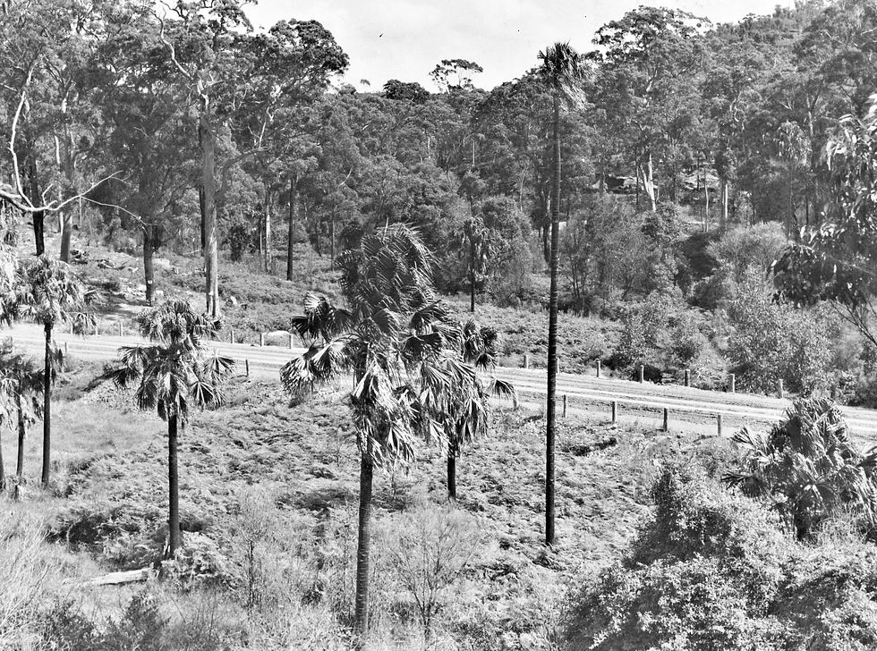
Wakehurst Parkway is a 14km state-owned arterial road between Seaforth in the south and Narrabeen to the north on Sydney’s Northern Beaches that has a reputation for frequent congestion, its vulnerability to flooding, and also for being haunted.

Named in honour of Lord Wakehurst (NSW Governor 1937-1946), construction began in October 1939 as an employment relief program. Timber felling and ground levelling works were repeatedly stalled due to World War II and also because of reported thefts of construction equipment.
Department of Main Roads (DMR) purchased 6,000 cubic yards of stone from a nearby council-operated quarry at Oxford Falls to use for surfacing the road. Previously, the region was virgin bushland, with several pig and poultry farms in the Oxford Falls area, where an abattoir was established to cater to them (1940-80).
The Parkway was officially opened on March 22, 1946.
The majority of the route is forested as it traverses through the Garigal National Park. The Parkway twice crosses Middle Creek and this section, known as ‘The Bends’, is where it’s most vulnerable to flooding after heavy rains, and is often closed to motorists (Transport for NSW reveal it is closed on average 11 times a year).
Upgrade
Begun in June 2026, Transport for NSW is currently overseeing an upgrade to improve safety, increase vehicle capacity and bolster flood resilience.
According to Northern Beaches Council, there are four key sections where improvements are being implemented which will result in flood mitigation measures, road widening, additional lanes and a new bridge crossing Oxford Falls Road (West).
Construction firm Ertech secured the $85.1 million contract to deliver the long-awaited improvement scheme (which local politicians have repeatedly highlighted in past election campaigns and residents and commuters have lobbied for decades).
Concerns have been raised by residents and community associations that the improvement works – principally the road widening - focus on the areas outside the central flood zone. Critics complain that the upgrade works don’t divert floodwaters away from The Bends, nor protect vulnerable wildlife crossing the Parkway.
For the latest updates on construction impacts and staging, you can check the official Wakehurst Parkway Improvements project webpage.
Aboriginal Camp
An Aboriginal encampment - the last community Aboriginal town camp in northern Sydney - existed until the 1950s adjacent to what became the Wakehurst Parkway at the western edge of Narrabeen Lagoon. The camp was nestled in the dense bushland now bordering Middle Creek Reserve.

Unlike similar settlements in Mosman and Brookvale, this camp survived into the mid-20th century because of its inaccessible location.
Before European arrival, Narrabeen Lagoon environs were an important region for the Garigal clans of the Upper Northern Beaches (and probably the neighbouring Gayamaygal clans to the south) due to its abundant food sources and safe habitat. Five primary sub-catchment creeks feed into Narrabeen Lagoon: Middle, Deep, South, Mullet and Nareen hosting a wide variety of aquatic life and nearly 200 species of birds.
The Garigal, a saltwater people (reliant on marine foods and coastal dwelling), traditionally ranged from Dee Why Lagoon north to Broken Bay and west to Terrey Hills, encompassing Pittwater, Cowan Creek and upper Middle Harbour Creek. Their clan totem is the whale.
The Aboriginal camp near Narrabeen Lagoon was targeted for eviction by authorities when the Wakehurst Parkway opened in 1946. In the 1950s, under the assimilationist policies of the era, the residents’ humpies (dome-shaped dwellings made of branches, bark, and foliage, often relying on a standing tree for structural support) were destroyed.
The Indigenous residents were forcibly relocated in trucks to Sydney's western suburbs.
A 30-hectare site was then cleared for the National Fitness Centre, followed later by construction of the Sydney Academy of Sport and Recreation, which was built in 1971. The latter campus features elite high-performance gyms and sports science units and is utilised for training by the Manly Sea Eagles rugby league team.

Aboriginal Artwork
There are several Aboriginal rock art sites within Garigal National Park close to the Wakehurst Parkway that feature ancient engravings on sandstone rocks.
Moon Rock is a protected Aboriginal site with around 50 engravings located on a high rocky ridge near Middle Creek in Ingleside, accessed via the Slippery Dip Trail.
According to Visit Sydney, “Moon Rock is a particularly significant site as it gives rare evidence of the Aborigines having astronomical knowledge, as it depicts eight lunar phases, along with Baiame the creator-spirit, local totems, food, weapons and whales and stingrays.”
Lizard Rock (or Patyegarang) is a relatively small site with 7 distinct motifs, featuring a prominent engraving of a kangaroo and six mundoes (footprints). It is located on a sandstone platform near Morgan Road in Belrose, west of the Wakehurst Parkway.
This area has been under threat of construction of a large 450-lot housing estate for several years, with the NSW Rural Fire Service repeatedly stating the 50-hectare zone is bushfire-prone with limited escape routes. A local campaign group is fighting the plans.
Bantry Bay Aboriginal Site, situated on a ridge just above Bantry Bay, features over 110 recorded figures spread across five sandstone platforms.
Motifs include mundoe (footprints), tools - axe, basket, boomerang, club, shield and spear - and wildlife - dingo, echidna, eel, fish, goanna, jellyfish, kangaroo, snake and a whale.
(Dingoes inhabited the Northern Beaches and greater Sydney region for thousands of years and were kept as companion animals by Indigenous peoples. However, European settlers targeted dingoes for eradication to protect their livestock, driving them out of the coastal region.)
However, the last time this reporter visited the site, the fencing surrounding the plateau had been knocked down and motorcycle tracks criss-crossed the ancient engravings.
Historically, there were concerns raised about damage to Aboriginal carvings by European settlers when the Parkway was first opened. A Letter to the Editor from prominent conservationist Michael Sawtell in the June 14, 1952 edition of The Sydney Morning Herald stated:
“Sir, I am told that motorists are destroying ancient aboriginal carvings by driving over them on Wakehurst Park Road in French's Forest. These carvings, I believe, come under the care of the Crown Lands Department, and this being so it is to be hoped that the Minister will see that these strange and interesting works are preserved.”
Murder at Deep Creek
In August 1994, a man who parked at Deep Creek Reserve, adjacent to the Parkway, was randomly murdered by a psychopath, who shot him in the heart with an arrow from a compound bow (archery bow with pulleys to increase its power).
Stephen Dempsey, 34, was killed by 22-year-old abattoir worker Richard Leonard, who lived in nearby Warriewood. The secluded Deep Creek Reserve was a known ‘gay beat’ (meeting spot for homosexuals) and this was why Leonard chose to target his victim.
During this time there were several murders of gay men around Sydney and on the Northern Beaches, including a notorious killing at North Head that NSW Police dismissed for years as a ‘suicide’.

According to the Sydney Morning Herald, Leonard “dragged the body down to a creek bed and left it there for some hours while he attended his mother’s birthday party. When he returned, he dismembered the body with the precision of someone who’d once worked in an abattoir, and ferried the parts on his motorbike back to his flat in Warriewood, where he stored them in his refrigerator.”
He kept Dempsey’s body parts frozen for three months, occasionally taking them out to “play” with them (as told to a cellmate) before dumping them in plastic bags in Pittwater, where they were later discovered.
Leonard went on to kill another man, a taxi driver on Collaroy Plateau, whom he stabbed 37 times after disputing the fair. Leonard’s girlfriend, Denise Shipley, 19, who was with him in the taxi, aided him in covering up the murders, for which she only served three-and-a-half years in prison. Leonard was jailed for life without hope of parole.
In a March 2008 Homicide Survivor’s Report, the victim’s friend, Peter Rolfe, outlined the horror of the incident:
“On the 2nd August 1994 my best friend and business partner, Stephen Dempsey, was murdered at Deep Creek, Narrabeen by Richard Leonard. Stephen's body was cut up and taken to Leonard's flat at nearby North Narrabeen and stored in his fridge for approx 3 and a half months.
“Leonard then murdered a taxi driver, Ezzedine Bahmad, at Collaroy Plateau. It was after this murder that he decided to remove Stephen's body, which he did and dumped it in Pittwater in 2 parcels wrapped in wire and loaded with large stones. Fortunately the torso floated and was found and later identified using DNA as being Stephen…”
Murder at Frenchs Forest
In April 1995, the body of Frances Tizzone, 21, was discovered dumped off Wakehurst Parkway at Frenchs Forest. A post-mortem revealed the Macquarie University student had been strangled to death. Her former boyfriend, John Serratore, 22, was later convicted of murdering her because she had broken off their relationship.
Forensic science was key to solving the crime – fibres from the carpet of Serratore’s car were matched to those on the soles of Tizzone’s shoes.
The original 1998 conviction was overturned due to legal error, but Serratore was found guilty at a retrial in 2000 and sentenced to a maximum of 20 years in prison for Tizzone’s murder. He was released after serving 13 years of his sentence.
Abductions of Hitch-Hikers
Two female friends told me a shocking story about an attempted abduction while they were hitch-hiking home one night along the Northern Beaches. They were picked up by a creepy predator who diverted his vehicle into the Wakehurst Parkway.
J*** and D*** (names withheld) were both very young, 16 and 18 respectively, and had been drinking in an Avalon club and were heading south to Collaroy to catch up with friends at the time of the incident.
J*** recalled: “We hitched from Bips Disco in Avalon. We were going to Sweet Fanny Adams at Collaroy. D*** sat in the middle [of the front seat of the car]. He turned off at Wakehurst Parkway. Me, being so pissed, said, ‘He’s taking us to Wendy's!’ (A friend, M***’s aunt).
“He keeps driving, pulls over at the Sports Centre. Quick-think D*** finds a fanbelt and starts hitting him. Then leans over and opens door, pushing me out of car. We roll down into a ditch and he's walking round, [saying] ‘I’m gonna' get you sluts!’
“We remain quiet, I piss on D***’s foot. He drives off. Leaving us to flag down a car. Unfortunately, we didn't go to police, but straight back to Bips.”
D*** recalled: “I don't think Fanny's was there but we were going to Collaroy to see who was there... I don't think it was Tween [suspected murderer of Trudie Adams – see below]…
“From what I can remember the guy was pretty straight-looking; small two-door car, nothing too seedy. I guess that’s why we thought it was ok. Lucky we weren't stupid enough to get in the back.
“He didn't say much and we were babbling-on drunkenly. When he turned up Wakehurst Parkway he was silent, driving fast. At one stage I tried to grab the steering wheel. He was holding it so tight, white-knuckling. I think we dodged a massive bullet!
“Thinking about it now, I would say that he was a psycho type. My mum always said it was one of Milat’s brothers [notorious serial killer Ivan Milat]. I wish we had gone to the police at the time. Some years back, when they [NSW Police] reopened the [Trudi Adams] case, I rang the number and told them what happened [to us].
“Didn't hear anything back. If we weren't drunk we might have been better witnesses. Also, if we weren't drunk we wouldn't have got in his car! It was a very lonely road back then!”
Around the same time, on 25 June 1978, 18-year-old Trudie Adams vanished after leaving a dance at the Newport Surf Life Saving Club on Sydney's Northern Beaches. She was last witnessed hitchhiking home, getting into a light-coloured 1977 Holden panel van on Barrenjoey Road.
The case is officially ‘unsolved’, although the most likely suspect was a serial rapist and career criminal named Neville Tween (also known as John Anderson), who lived in Terrey Hills. He was suspected of at least 14 rapes on the Northern Beaches. Throughout his long criminal career, he also served time for an aggravated sexual assault and abduction in 1975, as well as several other drug and property offenses. He was convicted in 2006 for conspiring to import 27 kilograms of cocaine and died in prison in 2013.
NSW Police have since offered a $250,000 reward for “anyone who provides information that leads to the arrest and conviction of the person/s responsible for Trudie's suspected death.”
However, the principle suspect, Neville Tween, was a paid police informant who may have received up to $100,000 from NSW Police for snitching on fellow drug dealers.
This is a probable reason why he avoided being arrested for interrogation after Adams’ disappearance.
The police officer handling him, former NSW Crime Commission investigator Mark Standen, was a career law enforcement officer who previously served as a detective with the Australian Federal Police.
Standen was later convicted in December 2011 of conspiring to import 300 kilograms of pseudoephedrine (a stimulant used in the production of ‘speed’ and ‘ice’) for which he was sentenced to a maximum of 22 years in jail, with a non-parole period of 16 years.
Standen was released from prison on 1 June, 2024
Haunted
Wakehurst Parkway also plays host to several ghost tales, centred around a woman in an early 1900s nurse’s uniform (or sometimes a nun’s habit), one of whom is known as ‘Kelly’.
Close to Wakehurst Parkway there is a road named Kellys Way that runs north from the Oxford Falls Cascades (near the junction of Morgan and Oxford Falls roads). However, Kellys Way is not named after the infamous ghost of the Parkway. Local records show it was cleared and partially built by the earliest handful of families who purchased acreage and settled in the isolated valley during the mid-1950s.
It is named after an ex-serviceman who bought a property there in 1956 with his soldier settlement following his service in WWII. He was employed on the construction crew building Wakehurst Parkway.
The ghost sightings tend to centre on two apparitions who appear late at night: one a young woman named Kelly (for unknown reasons), sometimes seen in a white dress or pyjamas; the other an elderly woman wearing a nun’s habit. However, the descriptions overlap and Kelly is sometimes observed wearing the nun’s uniform.
Furthermore, some reports state Kelly is a hitch-hiker, or, alarmingly, appears suddenly wandering in the middle of the road, apparently a dazed victim of a car crash. Then, if picked up, she refuses to get out of the car and grabs the steering wheel and turns the vehicle, causing it to run off the road and crash into trees.
Others recall Kelly appearing to stand on the roadside near Middle Creek Bridge, then, after they drive past (or sometimes through her!), she reappears in the rear-view mirror as if sitting in the back seat of the driver’s car.
It has recently been suggested Kelly and the old woman are the same but confusion lies in the interpretation of her clothing. Instead of a nun, perhaps Kelly was a nurse, wearing a uniform typical of the medical staff working at the Quarantine Station in the early 1900s.
A nun’s habit consists of an ankle-length black tunic, a white scapular (square-shaped cloth) covering the neck and shoulders, and a veil covering the head – white veil for novices, black for professed.
Whereas an Australian nurse’s uniform from the early 20th century typically consisted of a navy blue ankle-length dress (black for trainees), white collars and a white starched apron, and a white veil for those senior in rank, white caps for juniors.
Incidentally, Oxford Falls, gazetted as a suburb in 1902, was originally named ‘Bloodwood Gully’ by settler Alexander Bowen, who was granted 200 acres of land there in 1878.


Comments